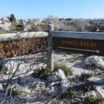
The S.S. Thomas T. Tucker Trails at Olifantsbos
Not a hull-of-a-lot to see
When Belinda and I were invited to hike the Olifantsbos Shipwreck Trail, in the Cape of Good Hope Nature Reserve, I was very excited indeedI set about reading all the blog posts that were available online about the trail. I also did some research into the history of the wrecks that we were going to encounter along the trail.
How to get there:
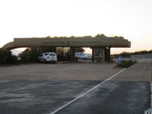
After entering through the main gate, drive along the main road for 1.9 km until you see the Olifantsbos turnoff to the right.
Turn right there and travel for a further 10.8 km until you reach the Olifantsbos parking area. There are directional signs along the way that show you where to go.
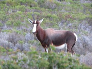
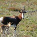
After taking the turnoff to Olifantsbos and just before we reached the parking area at the beach, we spotted a Bontebok grazing off to the right of the road. Not sure what happened to its one horn.
Opening times and Entrance Fees
The opening times of the Cape of Good Hope (Cape Point) Nature Reserve are:
| October – March | April – September | |
|---|---|---|
| Cape of Good Hope | 06h00 – 18h00 | 07h00 – 17h00 |
| Flying Dutchman Funicular | 09h00 – 17h30 | 09h00 – 17h00 |
| Two Oceans Restaurant | 09h00 – 17h00 | 09h00 – 17h00 |
| Curio Stores | 09h00 – 17h00 | 09h00 – 17h00 |
The entrance fees (August 2017) are as follows:
| Child | Adult | |
|---|---|---|
| Cape of Good Hope | R70 | R135 |
| Flying Dutchman Funicular | R25 (return), R20 (single) | R65 (return), R50 (single) |
The Speedy Review
In terms of the walking trail, Belinda and I found it very enjoyable, however it pains me to say that the actual experience of hiking the trail and seeing what was left of the shipwrecks was extremely underwhelming. To be perfectly honest, the shipwrecks on their own were not worth the gate fee into the Reserve. Although the history behind these vessels extremely interesting, it seems though that the wrecks themselves did not speak to Belinda or I. By all means visit the Cape Point Nature Reserve as it has a lot to offer in terms of beautiful scenery, fun activities and interesting things to see, but if you are only going to Cape Point to do the Shipwreck Trail, rather save your money for something else. On the day we hiked this route, there was a very strong head wind, so conditions were not conducive for a beach walk
This is the first blog post that I have written that contains a somewhat unfavourable review. Don’t get me wrong, there is still much that can be seen on the Shipwreck Trail in terms of fauna and flora, but this was after all the Shipwreck Trail and if you were wanting to do this trail to see impressive shipwrecks, then this is not the trail for you.
I did expect to find an information board about these vessels at the beginning of the trail or at the actual wreck sites that provided a brief history of how the vessel ended up running aground at Olifantsbos. There are no such information boards to be found and I believe that the trail is the poorer for it. The Reserve does have an official online guide to the Shipwreck Trail that does provide some very useful information, but is that information available to all who walk the trail? I very much doubt it. We also never found the wreck of the La Napoleon that was supposed to be lying close to the Olifantsbos parking area. According to a number of blog posts, her wooden frame and some of her cannons are often still visible. Without knowing precisely where to look, we failed to find any sign of her.
I don’t think that Belinda or I will ever do this trail again, unless we were already in the Reserve for something else and all our other plans fell through and our car happened to break down in the Olifantsbos parking lot.

Trail Ninometer
![]()
Nina rated this trail 0/5 paw prints, because there are no dogs allowed in the Cape Point Nature Reserve and she felt quite left out.
Brief History of the Shipwrecks on the S.S. Thomas T. Tucker Trails
The Wreck of the S.S. Thomas T. Tucker
“The S.S. Thomas T. Tucker was constructed at the Houston Shipbuilding Corporation in Houston, Texas. The vessel was launched on 31 August 1942, at a length of 422.8 ft. The S.S. Thomas T. Tucker was on its maiden voyage from New Orleans, Louisiana to Suez, Egypt with 8172 tons of cargo… for British forces in North Africa. While approaching Cape Point on November 27, 1942, the vessel ran aground near Olifantsbos in an unfortunate turn of events. Sailing through South African waters at a time when U-boat attacks were at a fever pitch, the crews were concerned about attacks. When one of the ships in the convoy reported having come under attack, the convoy started to zigzag in an attempt to evade torpedoes.
The crew of the S.S. Thomas T. Tucker thought they were nearing Cape Town (mistaking Albatross Rock for Robben Island) and although they were in a dense fog, the captain thought they were in Table Bay. Not knowing that their compass was off by an astounding 37⁰, the crew relaxed and during this time, the vessel ran aground. “
The S.S. Thomas T. Tucker was a Liberty ship. “The goal of the Liberty ship program was to produce ships at a rate quicker than the Axis Navies could sink them, and a total of 2751 Liberty ships were built from 1941 – 1945.” The S.S. Thomas T. Tucker was less than 3 months old when it ran aground and broke apart.
The information quoted above was obtained from the book Sea Ports and Sea Power: African Maritime Cultural Landscapes (edited by Lynn Harris) and available for purchase here.
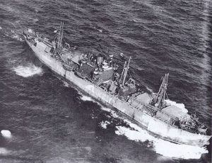
There doesn’t appear to be a photo available of the ill fated S.S. Thomas T. Tucker, but there is a photo of a sister Liberty ship, christened the SS John W. Brown. I have included it in this post to give you an idea of what the S.S. Thomas T. Tucker looked like before she ended her short sea life on the shores of Olifantsbos.
According to Michael Walker in his book Shipwrecks of the Far South, the S.S. Thomas T. Tucker had a cargo of “six Sherman tanks, spares, lorries, barbed wire and other war materials for the hardpressed Allies in the North African campaign”
There is speculation that the large amounts of iron on the vessel, which included the tanks and trucks, were responsible for causing the ship’s compass to be off by 037⁰.
For more interesting facts about how the S.S. Thomas T. Tucker ran aground you can visit this website.
The Wreck of the Nolloth
The following information was obtained from the Cape Point website
The wreck of the Nolloth is “one of the most visible wrecks of Cape Point, large parts of this wreck can still be seen on the beach at Olifantsbosch.”
“The Nolloth was a 347 ton Dutch coaster which struck Albatross Rock on 30 April 1965. The ship was loaded with fine whisky which the captain was wise enough to appreciate, so after the ship struck the rock and began to take on water, he steered it onto the beach in an attempt to save its precious cargo.
A Wasp helicopter was sent to identify the exact location of the ship, and it was then decided that the helicopters would transport the crew to safety as the ship was being battered by high seas.
It was the first time in South African maritime rescue history that helicopters were used to save the crew. (Until then, the rescue method was to launch ropes onto the ship and use a pulley to transport the crew onto the shore.)
The captain’s efforts were not in vain – most of the liquor on board was salvaged, and jealously guarded. But some of it made its way to an occasional lucky local.”
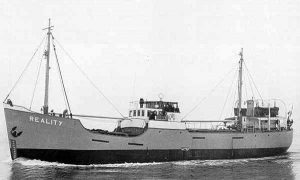
The Nolloth was previously named the Reality. It was renamed the Nolloth after starting a charter from Port Nolloth to Cape Town. Here is a photo of the Nolloth as the Reality.
The Wreck of the La Napoleon
I have again taken some interesting facts about the story of how the La Napoleon ran aground from this website, an online version of the book written by Michael Walker, Shipwrecks of the Far South.
“One of the first ships to run aground off the west coast of the future Cape Point Nature Reserve was the French privateer La Napoleon. This was the only known privateer to be wrecked on the South African coast.”
“In order not to fall into the hands of a British Naval frigate the Narcissus which had hunted her for two days, the Le Napoleon was run ashore near Olifantsbos at the end of the second day, 25 December 1805.”
There were 250 French marines onboard at the time. No lives were lost in this maritime disaster.
“The amazing fact was that no sooner had they recovered from their ordeal than they were seconded by the Dutch garrison, and within two weeks were involved in the Battle of Blaauwberg” against the invading British forces and were eventually captured.
Those are three very interesting stories about three very different vessels that ended up on the rocks at Olifantsbos. Now hear my story about our experience of the Thomas T. Tucker Shipwreck trail. Hopefully it will be just as interesting.
The Nitty Gritty
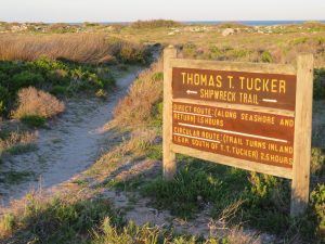
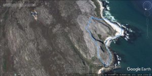
There are 3 Thomas T. Tucker Shipwreck hiking trails at Olifantsbos that all start at the parking area.
- Direct Route [1.5 hrs]
- Circular Route [2.5 hrs]
- Sirkelsvlei Route [3 hrs]
The first two trails start right at the parking area at the following GPS coordinates:
S 34⁰ 15.543′ E 018⁰ 22.928′
The third trail, Sirkelsvlei Trail, starts about 150 m away, at the entrance to the parking area. The start of the Sirkelsvlei Trail is also the end of the Circular Trail.
There is a long drop toilet situated near to the parking area inside a wooden structure. It was clean and in good condition and even had toilet paper! This is very handy to have at the start of a hiking trail and a huge advantage to hikers who have travelled a long distance to get to the Reserve.
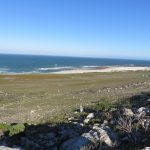
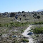
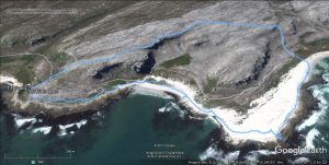
We hiked this trail on Sunday 27 August 2017 with 5 of our friends and family. The sun was shining and there was no chance of rain. The wind however was howling and bitterly cold. I wouldn’t be surprised if it was the wind that blew most of the pieces of these shipwrecks back into the sea. We started walking at 07h47. We chose to hike the Circular Route. From the parking area, the trail heads off to the left and towards the beach. The trail slowly curves to the left and starts to run parallel with the shore, just above the beach. The trail then tapers down and merges with the beach.There were no real directional markers here, but I knew from reading several reviews of the hike that the trail continued along the beach.
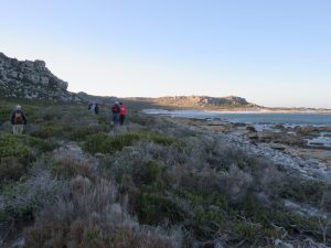
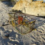
Our journey along the beach led to the discovery of a lobster (kreef) cage and some sort of ocean buoy that had both been washed ashore. From a distance, the buoy had looked like it could be a shipwreck.
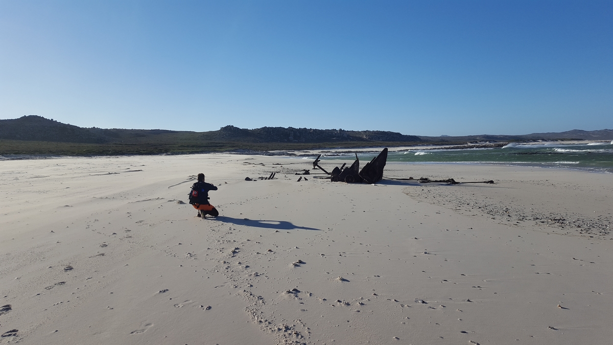
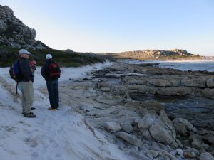
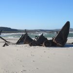
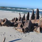
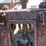
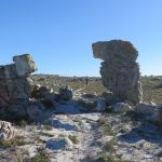
At 08h26, we reached a huge whale bone that had washed up on the beach. The whale bone was situated right before the wreck of the S.S. Thomas T. Tucker. The distance covered to that point was 1.9 km with a moving time of 30 minutes. The wind was blowing so strongly in our faces, at that point, that it made it really difficult to see and to take photos of the remains of the wreck which were scattered far and wide around us.
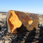

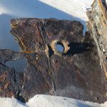
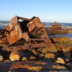

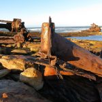
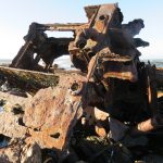

While there was no questioning the fact that there were large pieces of wreckage that still remained on the beach and on the rocks, it certainly no longer resembled the original vessel at all.
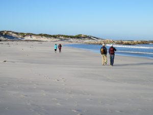
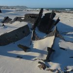
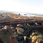
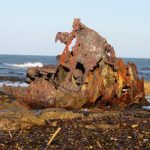
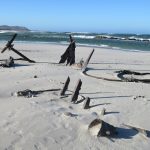
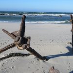
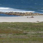
We continued walking along the beach and at 08h45, we came across what was left of the Nolloth wreck. The distance covered to that point was 2.8 km. From a distance, it appeared that the Nolloth was in a patch of quick sand and it was slowly being swallowed by the beach itself.

After taking another pounding from the wind while taking photos, we left the Nolloth and headed up the beach. The Sirkelsvlei Trail is visible from the Nolloth and is only about 150 from the wreck itself. The Sirkelsvlei Trail heads inland and pretty much straight up a small hill.
We could see a group of Bontebok crossing the trail in front of us as we ascended the hill. As we got closer, we noticed that one of the bonteboks had a baby. The wind was so strong at that point that I could not keep the camera stable when taking a photo of the family, hence the slightly blurry image.
We continued walking up the hill. I stopped and turned around and looked down at the wreck of the Nolloth on the beach and the trail we had just walked up. The Nolloth looked like the bones of a large fish swimming in the sand.
On reaching the top of the hill, at 09h09, we decided to have a snack break in the shelter of a few large rocks. The view from the top of the hill was beautiful. The distance covered at that point was 3.5 km with a moving time of 57 minutes. At 09h25, after a short stop consisting of coffee, water, bananas and energy bars, we headed off again along the trail. At 09h38, we reached a fork in the trail. The Circular Route back to the parking area continued straight and the Sirkelsvlei Trail ran off to the right. The distance covered to that point was 4.0 km with a moving time of 01h08. The elevation at that point was 74 m.

We had a group discussion on which way we were going to go. I voted to go right and on the longer Sirkelsvlei Route.
However the rest of the group made a collective decision to head back to the parking area, along the Circular Route, as it was bitterly cold and not all of the members of the hiking party had adequately warm clothing for the conditions.
The sign indicated that the trail would be completed in 1 hour. It actually took us only 30 minutes to reach the parking area from there.
I noticed then that the trail was marked with thin wooden poles with yellow paint on the top. The trail itself was still easy to see and follow.
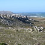
At 09h41, we continued along the walking trail. As we walked toward the end point, we spotted a collection of buildings on our left hand side.
There are several blog posts that say that these building were built during the period of the Second World War.
The buildings served as some kind of Observation Post.
The trail then descended quite quickly as the Olifantsbos Road came into view. On our left hand side, we could see a flock of Ostriches below near the Olifantsbos Guest House. They were so far away that they were not visible on the photo. We had covered a distance of 4.4 km.
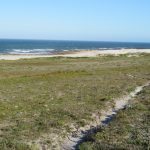
We continued to walk toward the edge of the hill. The ocean beyond the hill then came into view.
The trail zigzagged quickly down to the level of the tar road and exited at the start of the Sirkelsvlei Trail, at 10h08.
We walked across the tar road and into the parking area and reached the start / end of the Circular Trail at 10h10 with a total walking distance of 5.8 km.
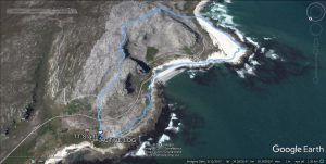
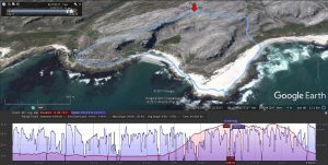
The Stats
The second half of the trail was marked by thin wooden poles painted with yellow paint near the top. I did not see any trail markings in the first half. There were no distance markers on any of the trails.
The route we walked had a total walking distance of 5.8 km. We walked a circular type route that started on the beach and ended by taking us inland and back to the start again.
Here are the hiking stats for this route:
| Trip Odometer | 5.8 km |
| Total Time | 02h23 |
| Moving Time | 01h33 |
| Moving Average | 3.7 km/h |
| Overall Average | 2.4 km/h |
| Max Speed | 9.6 km/h |
| Elevation | 1 m – 74 m |
I have attached a GPS trip log for the hike, including a side elevation profile. You can click on each picture to enlarge it.
Footnote: A few of the photos included in this blog were taken by Roderick Botha, including the feature photo.