Cape of Good Hope Overnight Hike – A Coastal Trail at the Tip of Africa
Cape of Good Hope Overnight Hike – A Coastal Trail at the Tip of Africa
Updated on 04 January 2020
The Cape of Good Hope Nature Reserve is formerly known as the Cape Point Nature Reserve. According to the official website, the Cape of Good Hope Nature Reserve has a rich and diverse history due largely to the search for a sea route to the East, around the tip of Africa.
“Portuguese explorer Bartholomeu Dias was the first to round the Cape Peninsula in 1488. He named it the ‘Cape of Storms’, for the notoriously bad weather… A decade later, Vasco da Gama navigated the same route and sailed down the coast of Africa, successfully opening a new trading route for Europe with India and the Far East. King John II of Portugal later renamed it the ‘Cape of Good Hope’ because of the great optimism engendered by the opening of this new sea route to India and the East.”
How to get there
The Cape of Good Hope Nature Reserve is located about 70 km from the city centre. There are really only two ways to get to the Cape of Good Hope Nature Reserve. The first is to follow the Main Road (M4) through, Muizenberg, Kalk Bay, Fish Hoek and Simon’s Town. The second is to take the route over Oukaapseweg and through Sun Valley and then to join with the Main Road (M4) in Glencairn. There is the option to travel over Red Hill instead of travelling through the center of Simon’s Town, but that route is a bit isolated and a little less safe than the marginally slower option through Simon’s Town itself. Clickety click over here for a pin the entrance gate at the reserve. This is where you will do the last bit of admin, get the keys for the overnight hut, sort out your slack packing baggage and park your car before you start your hiking journey through this beautiful reserve.
Opening Times and contact information:
The opening times of the Cape of Good Hope Nature Reserve for hiking, as on 01 January 2020, are:
| Monday – Sunday | 06h00 – 18h00 [Oct – March] |
| Monday – Sunday | 07h00 – 17h00 [Apr – Sept] |
| Standard Conservation Fee: | Adults: R320 Child: R160 [2-11 yrs] |
| SA Citizens (Discounted Rate) | Adults: R80 Child: R40 [2-11 yrs] |
| SADC Nationals | Adults: R160 Child: R80 [2-11 yrs] |
In order to qualify for the discounted rate, SA citizens will need to produce their SA ID cards or green ID book or SA driving license. For SADC Nationals you will need to produce your passport.
For general inquiries contact: +27 (0)21 7809010
Email: [email protected]
Twitter @CapePointSA
FB: http://www.facebook.com/capepointsa
No dogs are allowed in the reserve or on any of the hiking trails.
Bookings and Costs for the Hike
The hike itself costs R400 per person.
The daily conservation fee is R80 per person per day (SA citizens) unless you have a Wild Card, then there is no fee. We actually decided to buy a Wild Card specifically for this hike. The first time we hiked this route, it would have cost us almost the same amount for the daily conservation fee for the both of us, as an entire year’s valid Wild Card. In 2019, they reduced the fees for SA Citizens so it’s slightly more affordable without a Wild Card. With the Wild Card we purchased, we have 1 year’s access to all parks in the country for R1 055. SANParks has different Wild Card packages which you can find here. Click this link to buy a Wild Card online.
Slack Packing Option
You can choose to do this hike as a slack-packing trail as well, which all of our group decided to do. The fee (as on 01 January 2020) for this hike is R235 for 6 bags/items or less per hut. Thereafter it is R107 per additional bag/item over and above 6 bags/items. They will transport two bags of charcoal for free. Wood fires are not permitted on the reserve and that includes at the overnight huts. The portage fee is payable, in cash, at the Security Office located on the extreme left as you enter at the Main Gate, before you start the hike. If you don’t have the cash, you have the option of paying with a card at the boom gate for the portage and the SANParks official will give you the cash to take to the security office. You will be issued with a receipt immediately or one will be brought to your hut.
On booking the hike, you will be emailed an information sheet for the hike. There is a specific section relating to portage, and which items are and are not permitted. We used two very large duffel bags and placed all of our loose items (sleeping bags, small cooler bags and other items) in them.
Bookings for the Cape of Good Hope Overnight Hike can be made through the Buffelsfontein Visitors Center. Visit their website for more information. We struggled to get hold of them on the phone so it would be better to email them – [email protected]
The contact number for the Buffelsfontein Visitors Center on their website is no longer working. You will need to contact the Tokai office on (021) 712 7471 to make a booking.
Emergency Numbers
The number for the 24 hr control room, located at the main gate is (021) 780 9100 or you can call 086 110 6417. Please take note that the cell phone reception in the reserve is patchy.
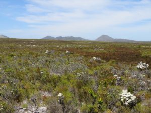
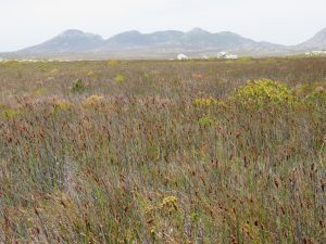
Brief Overview of Fauna and Flora in the Reserve
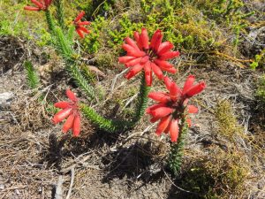
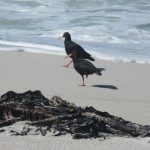
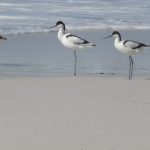
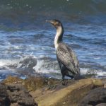
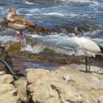
According to the Cape Town Magazine website, the Cape of Good Hope Nature Reserve “is 7750 hectares of wild coves, shimmering tidal pools, fynbos-covered valleys and diverse flora and fauna. There are 250 different bird species that make the area home, 1100 indigenous plant species whose roots burrow deep into the soil, a broad assortment of animal life that ranges from the nearly extinct bontebok to the deadly Cape cobra…”
We saw a huge variety of fauna and flora on our hike, some of which we had never seen before (see the photos in The Nitty Gritty section of this post)
The Speedy Review [tl;dr]
Feel like a 2 day hiking getaway without having to travel too far out of the city? Then the Cape of Good Hope Overnight Trail is for you.
The terrain is fairly easy and mostly flat, however the distances each day are quite long. You will need to be relatively fit to be able to enjoy this hike, as there are some tricky sections, and Day 2 has long stretches of the trail where you walk on beach sand which can get very tiring if your legs are not used to it. The wind and heat are important factors to consider when you book this hike, make sure you pick a time of year where the weather is going to be conducive to hiking long distances. There is very little shelter on both days, so you will be exposed to the sun, wind and rain for most of the day.
The overnight hut provides an extremely comfortable overnight resting spot, with a gas geyser for hot showers, comfortable beds and a well-equipped kitchen and braai area. The views are magnificent, and you can watch the sun-rise and sun-set from the comfort of your top-bunk or chair. There are 3 overnight huts that each sleep 6 people (Protea, Restio and Erica Huts)
This hike is well worth the fee, and a group of between 6 -12 people is recommended.
You have the option of doing either of the days first. Both times we have hiked this trail, we hiked the shorter day first (14km) and the longer day on Day 2 (20km). This leaves a relatively lengthy uphill/downhill for the end of the second day. You can, however, do the route the other way around. Our recommendation would be to look at the weather predictions and wind speeds for the days you plan on hiking this trail, and decide from there which day you will complete first.
If you are pressed for time and would prefer to watch a short video of the hike, have a look below:

Trail Ninometer
![]()
Nina rated this trail 0/5 paw prints, because there are no dogs allowed in the Cape of Good Hope Nature Reserve. She spent the night with her grandparents instead, and was spoiled rotten (as usual)
The Nitty Gritty
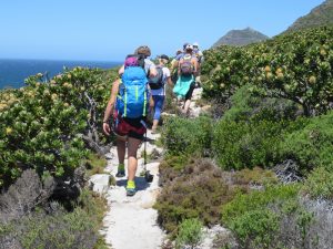
We first hiked this route on Boxing Day in 2017. We were invited by our cousins, and some family friends also joined us. We made up a hiking party of 12 which is a really good number for a hiking party. It’s not too small to warrant concern for safety on the trail and not too large that there is a danger of losing someone along the way.
We did this hike again on 31 December 2019 – 01 January 2020 with a smaller group of 6 hikers.
Unlike other hikes we have done in the past where it is ‘every person for themselves’ in terms of food, our cousin very cleverly organised that each person in the group brought something specific. This ensured there were no duplicates, but we had ALL the food we needed (and then some). It was delicious and a really good way to spread the load. We will definitely consider doing this in future for similar hikes. The second time we hiked this, we gave some guidelines to the hiking party on what food to bring, but each person sorted themself for catering.
This trail offers the option to slack pack on both days. The Reserve allows a limited amount of baggage to be transported to the overnight hut ahead of you and will bring the bags back to the start at the main entrance gate. I had mixed feelings about slack packing, but have grown more fond of the concept the older I get. They will drop off your bags at the overnight hut at about 09h00 on the first day and collect them from the hut around the same time the next day and return them to the main gate.
The first time that I did this hike, I chose to carry all my supplies and equipment with me, but handed over the communal food to be transported by vehicle to the overnight hut. Belinda chose to hand over her pillow and some warm clothes, but carried everything else, including 3 litres of water in her hydration bladder. Those 3 litres of water were key to staying the course late on Day 2 of the hike. When I look back on this hike, the limited slack pack option worked out well as far as the food was concerned, because each item was purchased in bulk to feed all of us. It would have made little sense for me to carry 3 loaves of bread, a brick of butter and a packet of marshmallows in my bag to feed me for two days (also…. carbs!). The second time we hiked this trail, we filled a large duffel bag with our sleeping bags, pillows, extra clothes and other smaller items that we would only need at the hut. It made the trail more enjoyable, having only a small amount in our day packs.
Day 1
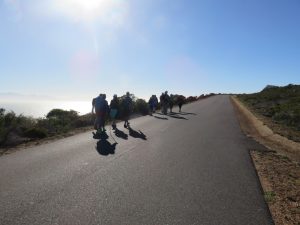
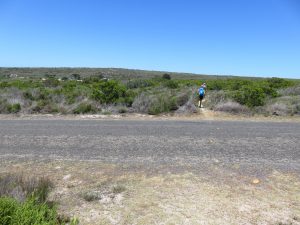
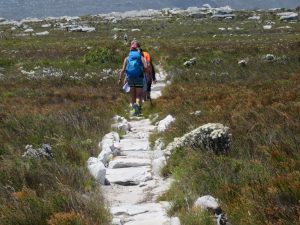
We began hiking at 07h45 from the main entrance gate and headed straight up the tar road. About 10 minutes and 715 m later, we turned left on to a marked trail that led us into a gravel parking lot. The trail continued on the other side of the parking lot.
On the second occasion of doing this hike (Dec 2019/Jan 2020), we left a little earlier at 07h20 which was better and we walked along the tar road until we reached the gravel parking area on the left and then turned off and followed the trail. It felt a lot easier doing it that way.
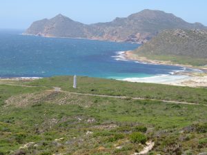
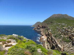
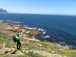
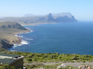
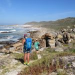
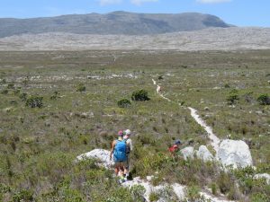
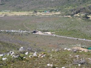
The trail took us up an increasingly steep incline with views of the rocky peninsula below us to our left. At 08h49, the trail started to turn towards the right and across a saddle towards Kanonkop. The distance covered to that point was 2.75 km with an altitude of 251 m and a moving time of 50 minutes. That was the first time that the overnight huts come into view on the trail. They were still very far away, but we then had a visual image of our overnight spot.
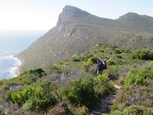
At 09h00, we stopped for a short break in the company of a few large boulders. We had covered a distance of 3 km which had taken us about an hour and a half to hike. At 09h10, we crossed another saddle and walked along a rocky outcrop. The wind was very strong at that point which made a few of us a little nervous about walking so close to the edge. Fortunately it was an onshore South Easterly and the worst case scenario would be that one of us would take off and land further inland in a thorny thicket. We had to hold onto our hats in the strong wind (losing them a few times along the way) and eventually opted for a buff to protect us from the sun as it was more steadfast in the wind.
The second time we did this hike, the wind was also strong and gusting, but we were grateful to have it as the temperatures were high throughout the hike.
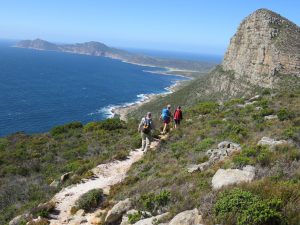
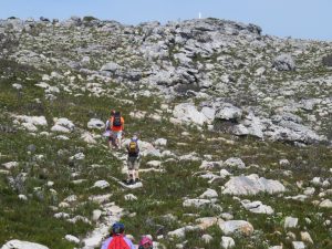
At 09h45, we stopped for another break with Kanonkop standing tall ahead of us. By that time, we had covered a distance of 4.3 km with a moving time of 01h30m.
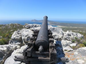
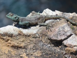
At 10h32, we stopped again for a break at an old cannon. The old cannon is about 6 km into the hike, and at the pace we were walking, takes about 02h45m to reach (including breaks) [Elevation 234 m]. We encountered a very curious lizard there who didn’t mind getting its picture being taken. At 10h45, we headed off on the trail again into the very strong wind.
At about 11h20, the trail started to move away from the coast and head inland toward the Buffelsfontein Visitor’s Center [8.2 km]. At that point, we had a clear view of the Da Gama Cross.
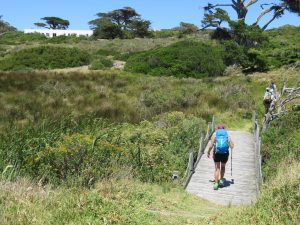
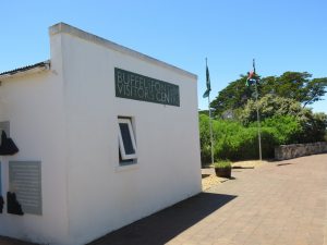
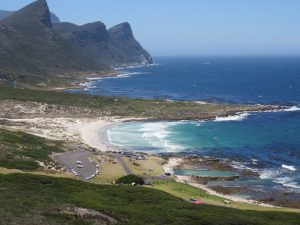
At 11h23, we crossed over the tar road leading to Bordjiesdrif. This is a lovely swimming and braaing spot in the reserve. The trail was marked on the tar surface with yellow painted shoe prints going in the opposite direction. At 11h30, we crossed over a wooden bridge which signaled our arrival at the Buffelsfontein Visitor’s Center. The distance to that point was 9.1 km with a moving time of 02h50m.
There is no water on the trail so the Buffelsfontein Visitor’s Center is not only a good place for a break, but it is also an opportunity to fill up your water bottles. A few of our hiking party took advantage of the *small coffee shop to order coffee, cold drinks and sandwiches. There is also an interesting exhibition room and museum that has displays of the local fauna and flora. The toilet facilities were top notch and clean. Belinda and I took advantage of the shade and closed our eyes for a few minutes.
*Sadly when we did the hike for the second time, we learned that the small coffee shop had closed down and there were no longer refreshments offered at the Visitors’ Centre. We all felt that SANParks is missing out on an opportunity not only to draw more people to the Visitors’ Centre by having a coffee shop, but also it would keep them there for longer so that they could really experience the interesting displays that the Visitors’ Centre has to offer. One example is a display on the SS Thomas T. Tucker, a Liberty ship that ran aground in the reserve. The wreck is still visible today and forms the focal point of the Shipwreck Trail. You can read more about the Shipwreck Trail here.
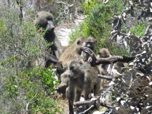
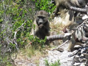
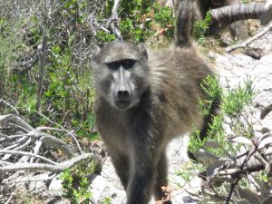
At 12h27, we started off on the trail again which continued on the other side of the Buffelsfontein Visitor’s Center parking lot. Not too long after we followed the path from the Visitor’s Center, we encountered the Buffelsfontein baboon troop coming towards us on the path. Our cousin used to track and observe this baboon troop during her tertiary studies and had already given us a rundown of how we should behave if we were to encounter a baboon troop. The most important of these guidelines was that we had to step out of the path of the baboons and not to make direct eye contact with any of them. All food items, cameras, and phones had to be packed away and we all had to try our best not to be worthy of closer inspection by any of the baboons. Basically look away and be boring. I surprised myself by how easily I could do that.
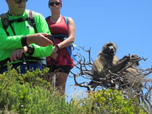
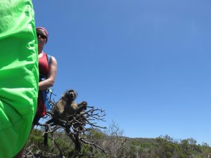
All seemed to go smoothly and the alpha male was about to pass by all of us when a baby baboon started shrieking. It appeared that either someone wasn’t following the baboon guidelines or the baby was bored and wanted to see what would happen if it stirred things up a bit. None of us were anywhere near the baby baboon, but the alpha male decided that we had something to do with the baby’s apparent distress and charged at two of our hiking party. Lindsay said it was a mock charge, but I am not sure the two hikers thought they were being mocked. Perhaps I misunderstood the meaning of the word. Luckily both hikers remained calm and stood their ground and the alpha male turned and followed his troop past the rest of us. That was until he decided to climb a tree right behind Belinda and begin a 15-minute inspection of her backpack and personal belongings while we all did our best mannequin challenge poses. I managed to take a photo of Belinda behind me while I was still facing forward. Belinda did well and kept calm and eventually, the alpha male moved off and we could continue with our hike physically unscathed.
[Photo credit to Adriaan for the contextualized ‘Baboon behind Belinda’ photo]

At 12h40, we crossed over another tar road and headed slightly to the right before entering the fynbos again [10.4 km]. We were descending nicely towards the sea, and the elevation at that point was 51 m.
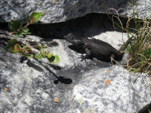
At 14h00, the trail started to ascend toward the overnight huts. Five minutes later, we arrived at the Southern Right whale viewing spot. We spent a few minutes there, but there were no whales to speak of. I did manage to take a photo of a rather colourful Southern Rock Agama instead.

After leaving the Southern Right whale viewing site, we walked up a wooden staircase and into a parking lot. Following the yellow shoe prints across the tar, we ascended the last stretch of the trail toward the overnight huts.
We reached the overnight huts at 14h32 after covering a distance of 14.5 km. The total moving time for the day was 04h20m with a total hiking time of 06h45m. You can allocate between 6-7 hours for the 14km leg of this hike, and 7-8 hours for the 20km day, depending which way round you do it.
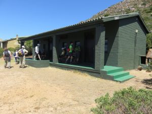
The Overnight Hut
When you get the keys for the overnight hut before starting the hike, you will know which hut you will be sleeping in. Erica hut is hut furthest to the right, and is separate from the others. You will need to look for the signboards for the hut you have been allocated.
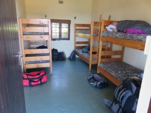
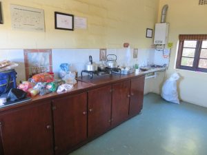
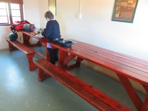
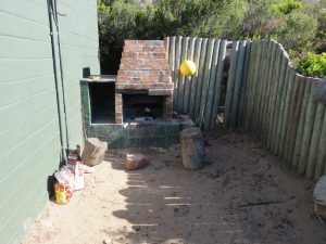
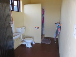
The overnight hut is a brick building that is divided into two sleeping quarters called Restio and Protea. Each sleeping quarters had 3 double bunk beds. There is an ablution facility on the extreme left and a kitchen and eating area on the extreme right, next to the outdoor braai. The hut is in good condition and the mattresses were comfortable. The kitchen is fully kitted out, so you don’t need to bring any cutlery or crockery with you.
There are other buildings that are dotted around the overnight hut that are in varying degrees of disrepair. None appear to be in use. It seems such a shame that they are not being used to their full potential considering where they are situated in the Reserve. Perhaps SAN Parks could look into renovating them to increase the number of people that are able to do the overnight hike or to improve the overall hiking experience for the 12 – 18 hikers that can currently do the trail each day.
The hut is fitted with a solar lighting system which is set to switch on when it gets dark. There is also a gas-geyser, so you can have a very welcome hot shower once you have finished hiking for the day. Just remember to use water sparingly. There are instructions in the hut for using the lights and geyser.
The braai area is really nice, and easily fitted the 12 of us in a circle, where we chatted about the days’ adventures.
Here is an idea of the food we took with us (with thanks to Lindsay for organising such a tasty menu):
- Bag of potatoes, a dozen eggs, bottle of mayonnaise, 4L milk
- Lettuce, cucumber, tomatoes, feta
- 100g instant coffee, cheddar cheese
- Boerewors, pork bangers, 18 x hot dog rolls, 1L plain yoghurt
- 18 x chicken kebabs, 2 x bags of apples, naartjies & bananas
- Tea, sugar, salt, 1 bag marshmallows, kebab sticks, butter, 3 x loaves of bread
We each carried our own lunch for the first day, and then used left-overs from the braai to make sandwiches and some snacks for lunch on Day 2.
The views from the hut are spectacular. Be sure to watch the sunset, you won’t be sorry.
Protea & Restio Huts
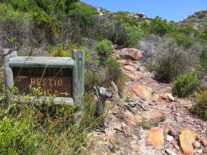

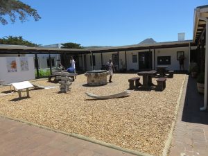
On the second occasion that we did this hike, we were only a group of 6 hikers. We were assigned to Erica which is the hut on the extreme right, on its own somewhat. Here is a look at how it is put together:
Erica Hut


Historical Building
Just above the Erica Hut are the remains of an observation post built in the days before South Africa’s secretive coastal radar station was up and running during WW2. They were apparently built strong enough to survive bombardment from enemy ships, long enough to alert friendly forces to repel the attack. Do yourself a favour and go and have a look at it. It still has most of its defensive battlements.


Day 2
We began hiking the next day at 08h25. The official website recommends that hikers leave the overnight hut before 09h00 in order to be able to complete the 20.5 km before dark. We retraced our steps to the tar road, turned left [385 m] and headed down toward the main thoroughfare through the Reserve.
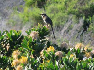
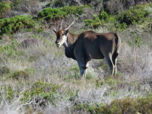
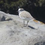
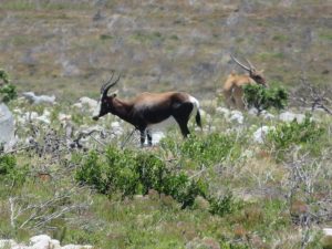
At 08h40, we walked around a wooden boom gate and crossed the tar road and into the fynbos on the other side [785 m]. It only took us 15 minutes to reach that point. A Cape Sugar bird paid us a visit while I waited for Belinda to take off a few layers. It was forecast to be a fairly mild day, but it was already hot that time of the morning. This was the first bird I had seen on the trail since we started the hike the previous morning. We got to see an Eland not too far from the path on our right hand side. A tourist minibus stopped as well and reversed toward the Eland for a closer look.
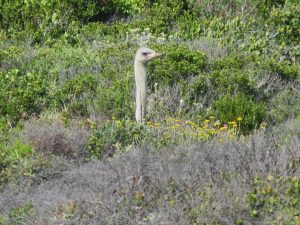
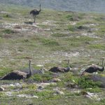
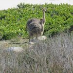
At 08h57, we walked across another tar road marked by the number 7 trail marker [1.8 km]. We spotted two ostriches to our left. The female was standing just off the tar road and the male was lying down in the fynbos.

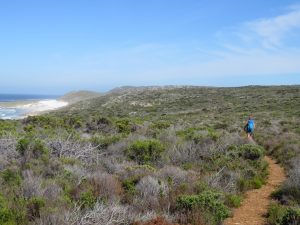
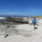
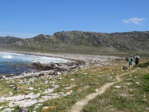
At 09h23, we reached a brick building adjacent to a parking lot. It turned out to be an ablution block and it was open. Some of the group were opposed to looking this gift horse in the mouth and popped inside to do the necessary. The rest of us walked around the right hand side of the block and headed across the parking lot to to a wooden staircase that led down to the beach. There was no signage indicating which way the trail went although it was assumed that it would be to the right. Half of our hiking party chose to turn immediately right and hike across the sand dunes, while the other half decided to walk straight across to the water line and then turn right. We followed the shore line for a short distance and then joined with a grassed path just a little further inland.
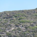
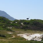
Those of us that went straight were spoiled by a rich and varied display of bird life perched on the rocks in the surf line. These later also included a female ostrich and her 4 youngsters. Higher up on the slopes of the hill to our right we got to see a herd of 5 Eland grazing.
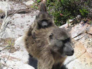
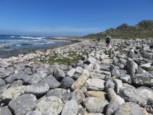
This was also turning out to be a comprehensive baboon encounter filled hike. As we walked along the shoreline, we noticed a lone large male baboon on the path. He moved off and headed up the fynbos covered hill on our right-hand side and watched as we walked past. Our thinking was that he was making sure that the coast was clear so that he could bring the rest of his troop down for a swim. The path took us through a section of boulders which was made easier by a few kind souls who had lined the boulders on either side to show the way.
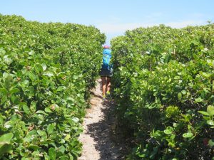
We continued walking a short distance from the high water mark and had to negotiate our way through a few bush tunnels. I had to bend my knees so much and crouch so far forward to get through these tunnels that my mind took me back to a previous Impi Challenge I did a couple of years back. There was a reason why I only did it once. It felt like I had run up a mountain without stopping after the unannounced obstacle course on the trail. I didn’t take a photo of them, but I did take a photo of the maze section through the bushes that followed immediately afterward.
A large portion of this part of the hike was good training for the Fish River Canyon hike which we are doing again in May this year. Lots of loose sand and rocks, very hot, dry and exposed.
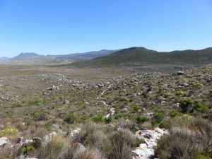
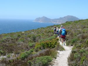
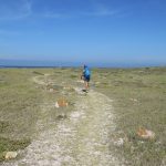
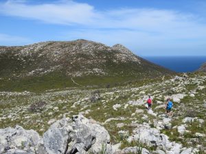
At about 11h40, the trail began to dog-leg to the right and move away from the beach. The distance covered to that point was about 8.8 km with a moving time of 02h15m. The total hiking time to that point was 03h25m. A few minutes later, we came to a sign that indicated left to the shipwreck and right for the Overnight trail. We turned right and the terrain changed quite dramatically from what we had being seeing on the shoreline. It became much drier, but we still seemed to be walking on beach sand although darker in colour. We did spot a Bontebok and an Eland just off the path to our right-hand side quite soon after heading inland.
At 12h00, we decided to have a break for lunch. We found a good spot just off the path and out of the sun in a cluster of large boulders. It also happens to be just around the halfway mark, as by this stage we had walked 10km [Moving time – 02h30m; Total time – 03h45m; Elevation – 44m] Belinda and I enjoyed sandwiches with leftover chicken kebab and a loose pork sausage each, followed by a boiled egg and a thick slice of cheese. Now I can tell you that it was not easy getting up from that meal, but we were only around halfway and there was a lot of hiking still to be done.
At 13h10, we crossed over a private tar road after covering a distance of 12.0 km. It had taken us around 5 hours to reach that point with a moving time of 3 hours.
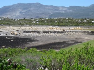
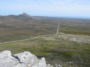
At 14h05, we came to a t-junction in the path [15 km]. The left path went to Olifantsbos, while the right directed us to the Main Gate. There was a dry salt pan or dam on our left-hand side with a lone eland standing in the middle of it. After turning right, we walked along a long and pencil straight path toward the Main gate and the two koppies [small hills] between us and the end of the trail. Johann, one of the hiking party, had warned us that there would be 2 ascents near the end of the hike, when we were tired and our legs were weary. They didn’t seem too high when we could see them in the distance, but hiking up them after nearly 20km in the heat was not as easy as we thought it would be.
At 14h45, we reached a gravel road and crossed over it [17 km]. At 14h50, we crossed a tar road at the base of the first koppie [17.3 km]. The elevation at that point was 81 m. At 15h36, we reached the trig beacon at the summit of the first koppie [268 m]. The distance covered to that point was 19.0 km and took a total of 07h20m. The elevation gain for that koppie was 187 m.


At 15h47, we reached the middle point between the two koppies [218 m] with a hiking distance of 19.4 km and total hiking time of 07h33m. We summited the second koppie at 16h00 [273 m]. The elevation gain for that koppie was 55 m with a total hiking distance of 20.0 km. The trail to the summit of the second koppie is not straight up – it is more of a terraced and winding trail so there are some flat sections for you to rest your legs.
At 16h20, we arrived back at the main entrance gate after hiking a total distance of 20.8 km which took us a smidgen over 8 hours to complete. Although the distance on day 2 was slightly longer than the average overnight hike, it was doable due to the relatively level terrain. The two koppies at the end were just a reminder to us all that a hike is never over until it is.
We collected our ported items from the office at the main entrance, said our good-byes and made our way home for a hot shower, and cuddle with Nina and a good night’s rest in our own bed.

The Stats
The Cape of Good Hope Overnight Hiking Trail is very well signposted on the first day. The same cannot be said for the second day, but if you keep your wits about you and follow the path it is not easy to get lost. We walked the trail in a roughly clockwise direction as advised by the Reserve staff, but for some reason the trail signage directed us in the opposite direction. We kept having to look behind us to see what the signs said. This is not an uncommon feature of South African National Parks signage so it didn’t bother us too much. A quick tut tut and a chuckle under our breath and it became a non-issue.
Here are the hiking stats for this overnight trail:
DAY 1
| Trip Odometer | 14.5 km |
| Total Time | 06h45 |
| Moving Time | 04h20 |
| Moving Average | 3.3 km/h |
| Overall Average | 2.2 km/h |
| Max Speed | 9.8 km/h |
DAY 2
| Trip Odometer | 20.8 km |
| Total Time | 08h05 |
| Moving Time | 05h36 |
| Moving Average | 3.7 km/h |
| Overall Average | 2.6 km/h |
| Max Speed | 9.3 km/h |
I have attached a GPS trip log for the hike. You can click on the images to enlarge them.

